
Page 72 - TransportationPlanUsetsGuide
P. 72
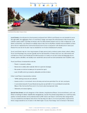
Local Street: SW San Mateo Terrace in Aloha


                Local Streets primarily provide direct access to adjacent land. While Local Streets are not intended to serve
                through-traffic, the aggregate effect of Local Street design can impact the effectiveness of the Arterial and
                Collector system when local trips are forced onto the Arterial street network due to a lack of adequate Local
                Street connectivity. Local Street connectivity maps in the Community Plans identify new Local Street connec-
                tions that are required by the Community Development Code in conjunction with development. New Local
                Streets that are not in this plan may be established via the land development process.

                Rural Local Roads may be miles long because of large parcels and a relatively sparse street network. Many
                Rural Local Roadways are unpaved (gravel) and the serviceability of these roads can vary with rainfall and
                maintenance. Rural Local Roads provide direct access to a variety of rural land uses including agriculture,
                forestry, quarry activities, low-density rural residential uses as well as rural commercial and industrial uses.

                Rural Local Street characteristics include:
              ADOPTED TEXT  •  Narrow lane widths with roadside ditches to provide drainage.
                   •  Paved or unpaved surfaces.


                   •  No access control and access points spaced far apart.
                   •  Lack of traffic calming measures, sidewalks and illumination.


                Urban Local Street characteristics include:
                   •  Traffic calming measures are allowed.
                   •  Access control is minimal with direct driveway connections permitted from all land use types.

                   •  A connected network of Local Streets is required as set forth in the Local Street Connectivity
                     Maps of the Community Plans and in the Community Development Code.

                   •  Sidewalks and street lighting.

                Special Area Streets are sub-categories of the Collector, Neighborhood Route, Commercial Street, and Local
                Street underlying functional classification designations. Special Area street designations are most frequently
                applied in transit-oriented overlay districts within 2040 Center and Station Community Area designations.
                They are identified on the Special Area Street Overlay Map and also in the Community Plans. Special Area
                Street design standards are included in the Washington County Road Design and Construction Standards.


       60                                 PART 3: TRANSPORTATION MODAL ELEMENTS
                                     Effective November 27, 2015 • Updated December, 15 2016