
Page 67 - TransportationPlanUsetsGuide
P. 67
ROADWAY ELEMENT CLASSIFICATIONS AND MAPS
This section provides descriptions and maps of facility classifications associated with the roadway system in Washington
County, including Functional Classification, Lane Numbers and Right-of-Way Protection, Special Area Streets, Long Term
Roadway Jurisdiction, Rural Roadway Enhancement Study Corridors, and Refinement Areas.
Functional Classification
Functional Classification introduces the two primary transportation functions of roadways, namely mobility and access,
and describes where different categories of roadways fall within a continuum of mobility-access. While these two func-
tions lie at opposite ends of the continuum of roadway function, most roads provide some combination of each. Most
travel occurs through a network of interdependent roadways, with each roadway segment moving traffic through the
system toward destinations. The concept of functional classification defines the role that a particular roadway segment
plays in serving this flow of traffic through the network, as illustrated in Figure 3-7. Roadways are assigned to one of
several possible functional classifications within a hierarchy according to the character of travel service each roadway
provides. Planners and engineers use this hierarchy of roadways to channel transportation movements through a high-
way network efficiently and cost-effectively.
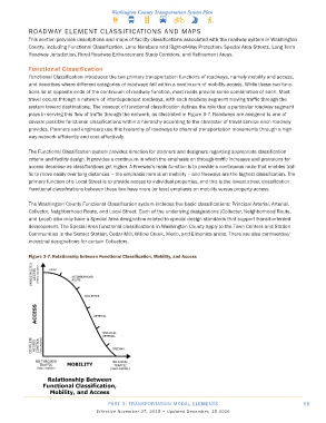
The Functional Classification system provides direction for planners and designers regarding appropriate classification
criteria and facility design. It provides a continuum in which the emphasis on through-traffic increases and provisions for
access decrease as classifications get higher. A Freeway’s main function is to provide a continuous route that enables traf-
fic to move easily over long distances – the emphasis here is on mobility – and freeways are the highest classification. The
primary function of a Local Street is to provide access to individual properties, and this is the lowest street classification.
Functional classifications between these two have more (or less) emphasis on mobility versus property access.
The Washington County Functional Classification system includes five basic classifications: Principal Arterial, Arterial,
Collector, Neighborhood Route, and Local Street. Each of the underlying designations (Collector, Neighborhood Route,
and Local) also may have a Special Area designation related to special design standards that support transit-oriented
development. The Special Area functional classifications in Washington County apply to the Town Centers and Station
Communities in the Sunset Station, Cedar Mill, Willow Creek, Merlo, and Elmonica areas. There are also commercial/
industrial designations for certain Collectors.
Figure 3-7: Relationship between Functional Classification, Mobility, and Access
PART 3: TRANSPORTATION MODAL ELEMENTS 55
Effective November 27, 2015 • Updated December, 15 2016