
Page 175 - TransportationPlanUsetsGuide
P. 175
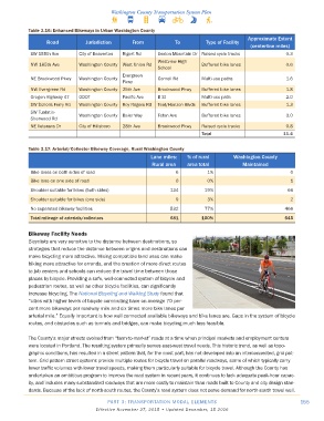
Table 3�16: Enhanced Bikeways in Urban Washington County
                                                                                               Approximate Extent
                   Road          Jurisdiction      From            To          Type of Facility
                                                                                                (centerline miles)
             SW 155th Ave      City of Beaverton  Rigert Rd  Sexton Mountain Dr Raised cycle tracks           0.3
                                                             Westview High
             NW 185th Ave      Washington County  West Union Rd              Buffered bike lanes              0.6
                                                             School
                                               Evergreen
             NE Brookwood Pkwy  Washington County            Cornell Rd      Multi-use paths                  1.6
                                               Pkwy
             NW Evergreen Rd   Washington County  25th Ave   Brookwood Pkwy  Buffered bike lanes              1.8
             Oregon Highway 47  ODOT           Pacific Ave   B St            Multi-use path                   2.0
             SW Scholls Ferry Rd  Washington County  Roy Rogers Rd  Teal/Horizon Blvds  Buffered bike lanes   1.3
             SW Tualatin-      Washington County  Baler Way  Teton Ave       Buffered bike lanes              3.0
             Sherwood Rd
             NE Veterans Dr    City of Hillsboro  28th Ave   Brookwood Pkwy  Raised cycle tracks              0.8
                                                                             Total                           11�4

            Table 3�17: Arterial/Collector Bikeway Coverage, Rural Washington County
                                                          Lane miles:   % of rural       Washington County
                                                          Rural area    area total           Maintained
             Bike lanes on both sides of road                      6           1%                              0
             Bike lane on one side of road                         0           0%                              1
             Shoulder suitable for bikes (both sides)            134          19%                             66
             Shoulder suitable for bikes (one side)                9           3%                              2
             No separated bikeway facilities                     532          77%                            466
             Total mileage of arterials/collectors               681         100%                            545


            Bikeway Facility Needs
            Bicyclists are very sensitive to the distance between destinations, so
            strategies that reduce the distance between origins and destinations can
            make bicycling more attractive. Mixing compatible land uses can make
            biking more attractive for errands, and the creation of more direct routes
            to job centers and schools can reduce the travel time between those
            places by bicycle. Providing a safe, well-connected system of bicycle and
            pedestrian routes, as well as other bicycle facilities, can significantly
            increase bicycling. The National Bicycling and Walking Study found that
            “cities with higher levels of bicycle commuting have on average 70 per-
            cent more bikeways per roadway mile and six times more bike lanes per
            arterial mile.” Equally important is how well connected available bikeways and bike lanes are. Gaps in the system of bicycle
            routes, and obstacles such as tunnels and bridges, can make bicycling much less feasible.


            The County’s major streets evolved from “farm-to-market” roads at a time when principal markets and employment centers
            were located in Portland. The resulting system primarily serves east-west travel needs. This historic trend, as well as topo-
            graphic conditions, has resulted in a street pattern that, for the most part, has not developed into an interconnected, grid pat-
            tern. Grid pattern street systems provide multiple routes for bicycle travel on parallel roadways, some of which typically carry
            lower traffic volumes with lower travel speeds, making them particularly suitable for bicycle travel. Although the County has
            undertaken an ambitious program to improve the road system in recent years, it continues to lack adequate peak-hour capac-
            ity, and includes many substandard roadways that are more costly to maintain than roads built to County and city design stan-
            dards. Because of the lack of north-south routes, the County’s road system does not serve demand for north-south travel well.

                                          PART 3: TRANSPORTATION MODAL ELEMENTS                                   155
                                     Effective November 27, 2015 • Updated December, 15 2016