
Page 171 - TransportationPlanUsetsGuide
P. 171
• Cycle Tracks: Cycle tracks provide added protection by separating motor vehicles and bicyclists where
travel speeds and/or motor vehicle traffic volumes are high. This type of facility appeals to a wider range
of bicycle users than a conventional bike lane. Cycle tracks are not currently addressed in the Washington
County Road Design Standards. However the Washington County Bicycle Facility Design Toolkit identifies
three types of cycle tracks:
› Protected cycle tracks are on-street bikeway facilities that provide the safety and comfort of multi-use paths
within the road right-of-way. This is accomplished by combining a painted buffer with a physical barrier such
as flexible bollards, a landscaped buffer, or a parking lane.
› Raised cycle tracks are grade separated. Commonly located above the adjacent travel lane and below the
sidewalk, they can also be found at sidewalk grade.
› Two-way cycle tracks allow for bicycle travel in two directions on the same side of the road.
Existing Bicycle Facility Network
Today the County’s major bikeway system is comprised of a variety of facilities and treatments on Collector and Arterial road-
ways. As in many growing areas, bicycle facilities in Washington County are still developing. In some cases there are complete,
continuous bike lanes; while in others, significant gaps exist in connections between facilities. The Regional Transportation
Functional Plan requires an inventory of existing facilities that identifies gaps and deficiencies in the bicycle system. Wash-
ington County performed a complete inventory of the County’s existing on-street bicycle facilities between 2011-2012 for the
Bicycle and Pedestrian Improvement Prioritization Project. The study examined all urban Arterial and Collector streets using
the latest aerial imagery to identify the presence/absence of on-street bicycle lanes five- to six-feet wide, and paved shoul-
ders at least four-feet wide. The inventory was reviewed by the public using an online interactive map that allowed visitors to
the project’s website to review the mapped inventory and comment on its accuracy, as well as provide other information like
system needs and route preferences. The following section provides a descriptive analysis of the existing bicycle network.
Arterials and Collectors
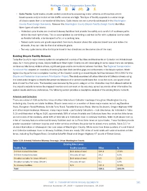
There are a total of 438 centerline miles of urban Arterial and Collector roadways throughout Washington County,
including city, County and state facilities. Bicycle lanes exist on a number of these major routes includ¬ing Baseline
Road, Evergreen Road/Parkway, Scholls Ferry Road, Tualatin-Sherwood Road, Murray Boulevard, Oregon Highway 99W
and other major roadways. However, many major roads – particularly Collectors – lack bike lanes. As indicated in Table
3.15 and illustrated in Figure 3-26, approximately 38% of urban Arterials and Collectors have five- or six-foot bike lanes
on both sides of the roadway, while 53% of Arterials and Collectors have no bikeway facilities. Table 3.16 shows that 11
miles of roadway feature enhanced bikeway facilities such as buffered bike lanes or cycle tracks. These facilities provide
greater separation between bicycles and motor vehicles and have the potential to attract more cyclists. Table 3.17 in-
cludes information on bikeways in the rural areas of Washington County. While more than three quarters of rural Arterial
and Collector roadways have no bikeway facilities, there are nearly 150 miles of rural roads with wide shoulders or bike
lanes, including Roy Rogers Road, Cornelius-Schefflin Road and Oregon Highway 47 (south of Forest Grove).
Table 3�15: Arterial/Collector Bikeway Coverage, Urban Washington County
Existing Bike Lanes
Facility Type Facility Location Miles %
5-6-foot marked bike lane Both sides of road 164.9 37.6%
5-6-foot marked bike lane One side of road 24.2 5.5%
Shoulder suitable for bikes (4-foot+) Both sides of road 9.5 2.2%
Shoulder suitable for bikes (4-foot+) One side of road 8.1 1.9%
No bikeway facilities N/A 231.3 52.8%
Total 438�1 100�0%
PART 3: TRANSPORTATION MODAL ELEMENTS 151
Effective November 27, 2015 • Updated December, 15 2016