
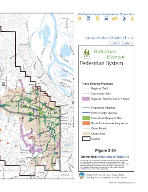
Page 165 - TransportationPlanUsetsGuide
P. 165
209TH ST
 HWY
                        ST HELENS RD                  179TH ST  AVE  11TH
 47                                                      41ST  AVE  199TH
 SHERM A NS
 M ILL RD
                                                SR-501                Transportation System Plan


                        RD                                                                 User’s Guide
                 ROCKY POIN T
                                      RD                   LAKESHORE
                                    REE DER  RD              A VE             Pedestrian
 DAIRY
          MORELAND RD          SAUVIE      GILLIHAN  LOWER                             Element
 CREEK
 RD
 RIV ER HWY                    RD  ISLAND            RIVER RD      Pedestrian System
 WILSON  PUMPKIN               MCNAMEE  RD

    R D             R OCK
 C EDAR CANYON RD    CREEK                          MARINE DR
 SHADYBROOK            RD       NE WBERRY RD  ST HELENS
 SUNSET HWY
  RIDGE RD
 WILSON RIVER HWY
       RD                                 RD         COLUMBIA BLVD
 GORDON RD  SCHOOL  HELVETIA  RD  GERMANTOWN  RD  SKYLINE BLVD  WILLAMETT E BLVD  Trails Existing/Proposed
 GALES
 R OY RD
                                                   LOMBARD ST
 HILLSIDE R D
 SCHEFFLIN RD  ZION CHURCH RD  JACKSON  MEE K RD  KWY  RD  WEST UNION RD SPRINGVILLE RD  THOMPSON RD  YEON AVE  GREELEY AV AVE  IN TERSTATE  Regional Trail
 KANSAS CITY R D
 CREEK RD
                                                                            Community Trail
 RD
 CORNELIUS  SUSBAUER  HORNECKER RD  EVERGR EEN RD BR OOKWOOD P  PASS  CORNELL RD  BETHANY BLVD  Regional Trail Refinement Areas
 THATCHER
 RD
 \\Emcgis\nas\GISDATA\Workgroups\GISPlanning\TSP_2035\TSP_User_Guide\ActiveTransElement\TSP_UserGuide_11x17_PED_county.mxd
 PACIFIC AVE  BASELINE ST  MAIN ST  CORNELIUS  185TH AVE  BURN SID E RD
 STRING TOWN
 R D                           WALKER RD  SUNSET HWY                         Pedestrian Parkway
                               JENKINS RD
                                                    PATTON RD                Street Scape Overlay
               TUALATIN  VALLEY HWY
 RD
 HILL  TONGUE LN  RD  AVE                  BEAVERTON HILLSDALE HWY  BLVD     Pedestrian/Bicycle District
 FERN  IOWA         209TH  FARMINGTON RD  MURRAY BLVD  ALLEN BLVD  VERMONT ST
 HWY    BRIDGE  RD                              RD  MULTNOMAH BLVD  TERWILLIGER  Rural Pedestrian Activity Areas
 HILLSBORO  ROOD  RIVER                      OLESON
 HILL
 OLD
 RD
 UNGER RD                              HALL BLVD                             Other Roads
 HWY
 47               RD        AVE
 RD                         175TH
 PATTONVALLEY
 DI XON MILL  RD  HILL          SCHOLLS FERRY RD                             Urban Area
 BALD PEAK RD     CLARK               WALNUT ST                              County
 RD
 This map displays an unofficial representation of elements  LAURELWOOD RD  LAUREL  RD  RD
 HWY 47
 RICHMOND
 adopted as part of Washington County Ordinance No. 783. It  SPRING  ROGERS  BULL  MOUNTA IN RD
 is not to be considered as the official Washington County  HILL  BEEF BEND RD  PACIFIC HWY DURHAM  RD
 Transportation System Plan. Please contact Washington  RD  SCHOL LS SHERWOOD RD  ROY
 MT
 County Long Range Planning at (503) 846-3519 with any  LEBEAU RD  TUALATIN RD  CHILDS RD  Figure 3-24
 questions regarding this map.  TUALATIN SHERWOOD RD        RD
 HWY 47                EDY  RD                                      Online Map: http://arcg.is/1ED2hD6
                          PACIFIC HWY       FERRY RD     STAFFORD  This product is for informational purposes and may not have been prepared
                 KR UGER RD                                        for, or be suitable for legal, engineering, or surveying purposes.  Users
                           SUNSET  BLVD           65TH AVE         of this information should review or consult the primary data and information
                 CHAPMAN                    BOONES        SCHAEFFE R  sources to ascertain the usability of the information.  Care was taken
                      RD                                           in the mapping but there are no warranties for this product.  However,
 1 inch represents 18,500 feet  NORTH VALLEY RD  HWY  F ERRY RD  MOUNTAIN  notification of any errors will be appreciated.
 0  2  4                         TOOZE RD         HOMESTEADER RD  RD
    HILLSBORO  PACIFIC HWY  ATER  HI LL R  BELL R D  GRAHAMS  RD        Planning and Development Services Division
 Miles  HWY 240            RD  LA DD               ADVANCE RD           Department of Land Use & Transportation
                                                                                           Effective: November 27, 2015