
Page 161 - TransportationPlanUsetsGuide
P. 161
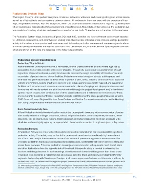
Pedestrian System Map
            Washington County’s urban pedestrian system consists of sidewalks, walkways, and crossings along and across streets,
            as well as off-street trails and connections between streets. All roadways in the urban area, with the exception of free-
            ways, are pedestrian routes. With few exceptions, within the urban area sidewalk installation is required by development
            when roadways are reconstructed for a development or capital project. Meanwhile, in the rural area, the pedestrian sys-
            tem consists of roadway shoulders and paved or unpaved off-street trails. Sidewalks are not required in the rural area.


            The Pedestrian System Maps, included as Figures 3-24 and 3-25, identifies the future off-street trail network intended
            for utilitarian, recreational, and other types of walking trips. The map also indicates areas of above-average pedestrian
            activity in the urban unincorporated and rural areas, and delineates particular roadways and roadway segments where
            enhanced pedestrian features are desired because of land use context and/or transit service. Specific pedestrian clas-
            sifications shown on the map are described in the following paragraphs.


                Pedestrian System Classifications
                Pedestrian/Bicycle District
                Within the urban unincorporated area, a Pedestrian/Bicycle District identifies an area where high use by
                pedestrians and cyclists is either observed or intended. This activity may be due to a combination of exist-
                ing and/or proposed land uses, density, land use mix, community design, availability of transit service and/
                or provision of pedestrian and bicycle facilities. Pedestrian-oriented design of streets, public spaces and
                land uses are generally required in these areas to provide a safe, direct, efficient, comfortable and attractive
                walking environment. Secure short-term and long-term bicycle parking is generally required and supporting
                facilities such as lockers and showers are recommended at places of employment. Appropriate features and
                dimensions will vary by context and shall be determined through the project development and/or land devel-
                opment review process with consideration of other classifications and in reference to the Community Plans
                and Community Development Code. Pedestrian/Bicycle Districts cover the same geographic areas as Metro
                2040 Growth Concept Regional Centers, Town Centers and Station Communities as adopted in the Washing-
                ton County Comprehensive Framework Plan for the Urban Area.
                                                                      13

                Rural Pedestrian Activity Area
                A Rural Pedestrian Activity Area is a location outside the urban growth boundary with a concentration of pedes-  ADOPTED TEXT
                trian activity related to a village, crossroads, school, religious institution, community center, farmstand, recre-
                ation area, trail or other cultural feature. Treatments such as marked crosswalks, mid-block crossings, wide
                shoulders and warning signage may be appropriate in these locations, subject to engineering and policy review.

                Pedestrian Parkway
                A Pedestrian Parkway is a major urban thoroughfare (typically an arterial) that has the potential for significant
                pedestrian activity. This activity may be due to the provision of transit service, a relatively high intensity and
                mix of land uses, and/or the continuous nature of the route as it passes through one or more communities.
                Enhanced pedestrian facilities are encouraged to facilitate a safe, comfortable walking environment along and
                across these roadways. Enhanced pedestrian crossings are recommended to help people reach transit stops
                and other destinations from the opposite side of the street. Site-specific study is needed to determine the
                locations and design features for such crossings. Consideration of sidewalk widths greater than those shown
                in adopted road standards is recommended on a context-sensitive basis, particularly on Pedestrian Parkway
                segments that overlap with Streetscape Overlays. In all cases, appropriate features and dimensions will vary by
                context and shall be determined through the project development and/or land development review process with
                13  Metro’s Regional Active Transportation Plan (RATP) and Regional Transportation Plan (RTP) show Pedestrian Districts and Bicycle
                Districts on separate maps, though they cover the same geography. The TSP does not show Pedestrian/Bicycle Districts within cities.


                                          PART 3: TRANSPORTATION MODAL ELEMENTS                                    141
                                     Effective November 27, 2015 • Updated December, 15 2016