
Page 40 - TransportationPlanUsetsGuide
P. 40
Roadway Element
Washington County’s transportation system includes nearly 1,300 miles of roads, shared by motor vehicles, bicycles,
pedestrians, trucks, and public transit. The County’s roadway system includes a wide variety of roadway types – from
major urban boulevards to gravel rural roads. The Roadway Element provides for an integrated network of complete
streets that provide an interconnected transportation system for all modes and users. “Complete streets” are designed
to accommodate use by all travel modes, including automobiles, bicycles, freight delivery vehicles, transit vehicles, and
pedestrians of all ages and abilities.
TRANSPORTATION SYSTEM PERFORMANCE
Performance Targets and Standards
Regional Performance Targets
The Metro 2014 Regional Transportation Plan (RTP) identifies a number of regional performance targets for transporta-
tion through 2040. Washington County must work towards achievement of the targets included in the RTP. In addition
to the mobility targets identified in the 2014 RTP, Metro’s Regional Transportation Functional Plan (RTFP) establishes
regional performance targets and standards. The RTFP establishes two primary performance targets: Non-Single Oc-
cupant Vehicles (modal performance), and Roadway Mobility Operating Standards (mobility performance), as directed
in RTFP Section 3.08.230. Each city and county in the region must demonstrate that solutions adopted in their respec-
tive transportation system plans will achieve progress toward the regional targets and standards, and shall include the
regional targets and standards or alternatives to them in their respective transportation system plans. The Washington
County TSP is consistent with the RTFP and the 2014 RTP.
Mobility Standards
Level of Service
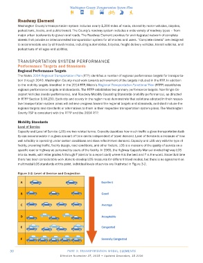
Capacity and Level of Service (LOS) are two related terms. Capacity describes how much traffic a given transportation facil-
ity can accommodate in a given amount of time and is independent of travel demand. Level of Service is a measure of how
well a facility is operating under certain conditions and does reflect travel demand. Capacity and LOS vary with the type of
facility, prevailing traffic, facility design, road conditions, and other factors. LOS is a measure of the quality of service on a
specific road or highway as perceived by users of the facility. In 1965, the Highway Capacity Manual divided highway LOS
into six levels, with letter grades A through F (similar to a report card) where A is the best and F is the worst. Since that time
there has been considerable work done to develop LOS measures for different travel modes, but there is no agreement on
multimodal LOS standards at this point. Individual levels of service are illustrated in Figure 3-2.
Figure 3-2: Level of Service and Congestion
30 PART 3: TRANSPORTATION MODAL ELEMENTS
Effective November 27, 2015 • Updated December, 15 2016