
Page 203 - TransportationPlanUsetsGuide
P. 203
ROY RD
SCHOOL RD RD G ERMANTO WN RD
HILLSIDE RD
ZIONCHURCH RD MEEK RD HELVETIA WEST UNION RD
KEMPER RD JACOBSON RD KAISER
WREN RD JACKSON SPRINGVILLE RD RD
SCHE FFLIN RD EVER GREEN RD PKWY ROCK LAIDLA W RD
VERBOORT RD GLENCOE CREEK BLV D BLVD THOMPSON RD
THATCHER
GALES
PURD IN RD
RD
RD SUSBAUER RD HORNECKER RD RD 15TH AVE 25TH AVE BROOK WOOD 2 29TH EVERGREEN PKWY BETHANY Transportation System Plan
CREEK RD
MARTIN CORNELIUS A VE BRONSON RD SAL T ZMA N RD User’s Guide
D AVID HILL RD
BO NNIELN SUNRISE LN CORNELL RD
A VE
E ST MAIN ST OAK ST 1ST AVE 5TH AVE GRANT ST 231ST QUATAMA RD 173RD AVE LEAHY R D Transit Element
MAIN ST
RD 19TH AVE 4TH AVE BASELINE ST OAK ST BASELINE RD
RIT CHEY B ST ELM ST 10TH AVE WALNUT ST 32ND AVE BROOKW OO D ROCK RD 158TH AVE PARK WAY BARNES R D
ST RINGTOWN RD
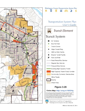
HWY AVE IMLAY AVE LOIS ST JOHNSON ST 185TH AVE 170TH AVE WALKER RD CEDARHILLS BLVD Transit System
RD G OLF COURSE HILLSBORO MINTER B RIDGERD DAVIS RD 67TH AVE ALEXANDER ST 153RD DR CANYON RD Air Terminal
FERN HILL RD TONGUE LN RD BL VD KINNAMAN RD 6TH ST BEAVERTON HILLSDALE HWY Bus Terminal
BRIDG E CENTURY 209TH AVE 198TH AVE ROSA RD DIVISION ST ALLEN BLVD Transit Center
5TH ST
ROOD ROSEDAL E RD OAK ST DAVIS RD MURRAY BLVD Major Transit Stop
JOHNSON SCHOOL RD
IOWA
BANY RD 155TH AVE DENNEY RD RD MAX w/ Bike Facility
HIL L R D
SCOGGIN S VALLEY RD
BURKHALTER RD
RIVE R RD RIGER T RD A VE OLESON Bicycle Transit Facility
UNGER RD FARMINGTON RD KEMMER RD NI M BUS CASCADE 80TH AVE
PA TTON VALLEY RD WEIR RD DAVIES RD AV E OAK ST Park and Ride
GASTON RD DIXON MILL RD Peak Period Bus Service
HILL RD 121ST AVE AVE Regular Bus Service
\\Emcgis\nas\GISDATA\Workgroups\GISPlanning\TSP_2035\TSP_User_Guide\ActiveTransElement\TSP_UserGuide_11x17_TRANSIT.mxd
BALD PEAK RD C LARK TILEFLAT RD BARROWS RD WALNUT ST 72ND Frequent Bus Service
LAURELWOOD R D
SPRING
LAUREL RD SCHOLLS F ERR Y RD ROSH GAA R DE ST
A K RD
BULL MOUNTAIN RD PACIFIC HWY HALL BONITA RD Existing High Capacity Transit
HILL
150TH AVE
High Capacity Transit Study Corridor
ROY ROGERS RD BEEF BEND RD DURHAM RD Community Connector Service Area
RD
BLVD
RD E L SNER R D Other Roads
VANDERSCHUERE RD
SEIFFERT SCHOLLS-SHERWOOD TUALATIN RD County
RD
This map displays an unofficial representation of elements CIPOL HERMAN RD TETON Urban Area
adopted as part of Washington County Ordinance No. 783. It E RD SAGERT ST
is not to be considered as the official Washington County EDY RD TUALATIN SHERWOOD RD AVE Figure 3-29
AVERY ST
Transportation System Plan. Please contact Washington RD
County Long Range Planning at (503) 846-3519 with any ELWERT RD FERRY 65TH AVE
questions regarding this map. TONQUIN Online Map: http://arcg.is/1ED3I4g
SUNSET BLVD BOONES This product is for informational purposes and may not have been prepared
for, or be suitable for legal, engineering, or surveying purposes. Users
PINEST
CHAPMAN RD RD GRAHAMS FERRY RD of this information should review or consult the primary data and information
sources to ascertain the usability of the information. Care was taken
notification of any errors will be appreciated.
1 inch represents 10,000 feet ELLIGSEN RD in the mapping but there are no warranties for this product. However,
0 1 2
Department of Land Use & Transportation
Miles
Planning and Development Services Division
Effective: November 27, 2015