
Page 199 - TransportationPlanUsetsGuide
P. 199
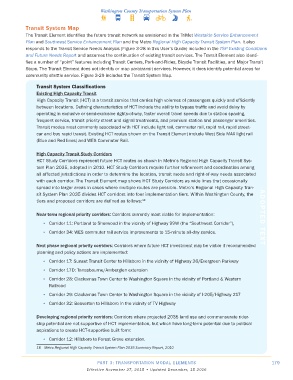
Transit System Map
            The Transit Element identifies the future transit network as envisioned in the TriMet Westside Service Enhancement
            Plan and Southwest Service Enhancement Plan and the Metro Regional High Capacity Transit System Plan. It also
            responds to the Transit Service Needs Analysis (Figure 3-28 in this User’s Guide) included in the TSP Existing Conditions
            and Future Needs Report and assumes the continuation of existing transit services. The Transit Element also identi-
            fies a number of “point” features including Transit Centers, Park-and-Rides, Bicycle Transit Facilities, and Major Transit
            Stops. The Transit Element does not identify or map paratransit services. However, it does identify potential areas for
            community shuttle service. Figure 3-29 includes the Transit System Map.

                Transit System Classifications
                Existing High Capacity Transit
                High Capacity Transit (HCT) is a transit service that carries high volumes of passengers quickly and efficiently
                between locations. Defining characteristics of HCT include the ability to bypass traffic and avoid delay by
                operating in exclusive or semi-exclusive rights-of-way, faster overall travel speeds due to station spacing,
                frequent service, transit priority street and signal treatments, and premium station and passenger amenities.
                Transit modes most commonly associated with HCT include light rail, commuter rail, rapid rail, rapid street-
                car and bus rapid transit. Existing HCT routes shown on the Transit Element include West Side MAX light rail
                (Blue and Red lines) and WES Commuter Rail.

                High Capacity Transit Study Corridors
                HCT Study Corridors represent future HCT routes as shown in Metro’s Regional High Capacity Transit Sys-
                tem Plan 2035, adopted in 2010. HCT Study Corridors require further refinement and coordination among
                all affected jurisdictions in order to determine the location, transit mode and right-of-way needs associated
                with each corridor. The Transit Element map shows HCT Study Corridors as wide lines that occasionally
                spread into larger areas in cases where multiple routes are possible. Metro’s Regional High Capacity Tran-
                sit System Plan 2035 divides HCT corridors into four implementation tiers. Within Washington County, the
                tiers and proposed corridors are defined as follows: 18

                Near term regional priority corridors: Corridors currently most viable for implementation:    ADOPTED TEXT
                   •  Corridor 11: Portland to Sherwood in the vicinity of Highway 99W (the “Southwest Corridor”),

                   •  Corridor 34: WES commuter rail service improvements to 15-minute all-day service.

                Next phase regional priority corridors: Corridors where future HCT investment may be viable if recommended
                planning and policy actions are implemented:
                   •  Corridor 17: Sunset Transit Center to Hillsboro in the vicinity of Highway 26/Evergreen Parkway

                   •  Corridor 17D: Tanasbourne/Amberglen extension
                   •  Corridor 28: Clackamas Town Center to Washington Square in the vicinity of Portland & Western
                     Railroad
                   •  Corridor 29: Clackamas Town Center to Washington Square in the vicinity of I-205/Highway 217
                   •  Corridor 32: Beaverton to Hillsboro in the vicinity of TV Highway


                Developing regional priority corridors: Corridors where projected 2035 land use and commensurate rider-
                ship potential are not supportive of HCT implementation, but which have long-term potential due to political
                aspirations to create HCT-supportive built form:

                   •  Corridor 12: Hillsboro to Forest Grove extension.
                18   Metro Regional High Capacity Transit System Plan 2035 Summary Report, 2010


                                          PART 3: TRANSPORTATION MODAL ELEMENTS                                    179
                                     Effective November 27, 2015 • Updated December, 15 2016