
Page 118 - TransportationPlanUsetsGuide
P. 118
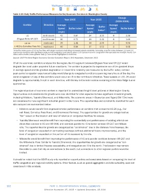
Table 3.10: Daily Traffic Performance Measures for Key Economic Corridors in Washington County
                                                                                                 Change
                                                      Year 2005            Year 2035
                                                                                               (2035-2005)
                    Corridor         Direction  Average                Average            Average
                                                                                  Buffer
                                                 Speed   Buffer Index*  Speed    Index*    Speed    Buffer Index*
                                                 (mph)                  (mph)              (mph)

                      I-5           north-bound   42         0.87         34      3.10       -8         2.23
               (Elligsen Rd to OR 217)  south-bound  44      0.72         36      2.41       -8         1.69
                     US 26           eastbound    39         1.41         36      2.05       -3         0.64
             (I-405 to Cornelius Pass Rd)  westbound  40     0.84         37      1.52       -3         0.68
            *A buffer index score of 0.0 is free-flow, with larger numbers indicating increased speed variability. Generally, a buffer index between 1.0 and 2.0
            represents corridors with significant peak period congestion and values above 2.0 represent severe congestion that spreads into multiple hours. Cor-
            ridors with a buffer index greater than 2.0 are shown highlighted in bold font.
            Source: ODOT Portland Region Economic Corridor Evaluation Report, DKS Associates, December 2011
            Of all the economic corridors analyzed for the region, the I-5 segment between Elligsen Road and OR 217 would
            degrade the most under projected future conditions. The corridor is projected to experience one of the greatest drops
            in average speed and the greatest degradation in travel-time reliability (as measured by the buffer index). Limited
            peak-period congestion experienced today would change to congested conditions spanning many hours of the day; the
            worst congestion of any of the corridors would occur on I-5 in the northbound direction. Travel speeds on U.S. 26 would
            degrade by approximately 3 mph in each direction, with the key bottleneck location remaining at the Vista Ridge tunnel
            approaches.

            The regional picture of economic centers is important to understand freight travel patterns in Washington County.
            Opportunities and constraints for growth were also identified for sites expected to have significant industrial growth,
            including Hillsboro, Tualatin/Sherwood, and Wilsonville. The economic areas in Beaverton and Tigard/SW 72nd were
            not considered to have significant industrial growth in the future. The opportunities and constraints identified for each
            site analyzed are summarized below:
              •  Hillsboro would benefit from improved arterial performance on corridors that connect to US 26 (e.g., Cor-
                 nell Road, Cornelius Pass Road, and Brookwood Parkway). The opportunities for growth are categorized as
                 “fair” based on the location and level of reliance on congested facilities for access.
              •  Tualatin/Sherwood would benefit from improving the connectivity and performance of existing arterial cor-
                 ridors that connect to I-5 and OR 99W, and corridors parallel to I-5 to better connect OR 217 and Wilson-
                 ville. The opportunities for growth are categorized as “constrained” due to the distance from freeways, the
                 level of congestion expected on connecting roadways (without additional future improvements), and the
                 level of congestion expected on the portion of I-5 accessed by the site.

              •  Wilsonville would benefit from improving the performance of I-5 and parallel corridors between OR 217 and
                 the Willamette River. Similar to Tualatin/Sherwood, the opportunities for growth are categorized as “con-
                 strained” due to limited freeway accessibility, and congestion on I-5 to the north. This location may remain
                 favorable to uses that rely on connections to the south; but connections to other regional portals would be
                 limited.

            It should be noted that the ODOT study only reported on opportunities and constraints based on comparing the level of
            traffic congestion and regional mobility options. Other factors, such as parcel aggregation and site suitability, were not
            considered in this analysis.


      102                                 PART 3: TRANSPORTATION MODAL ELEMENTS
                                     Effective November 27, 2015 • Updated December, 15 2016