
Page 53 - TransportationPlanUsetsGuide
P. 53
BANKS RD SCHOOL RD
MOUNTA INDA LE RD SHADYBROOK R D
DERSHAM RD JACKSON HELVETIA RD
CLAPSHAW HILL RD KA NSAS CITY GREENVILLE RD GORDON RD RD WEST UNIO N RD PHILLIPS RD Transportation System Plan
ROY RD
HILLSIDERD
R D
GALES CREEK RD
ZION CHURCH RD GLENCOE MEEK RD CORNELIUS PASS RD 185TH AVE KAIS ER User’s Guide
RD
KEMPER RD WREN RD RD Roadway Element
VERBOORT RD RD E VERGREEN RD PKWY ROCK LAI DLA W RD
PURD IN RD CORNELIUS SCHEFFLIN AVE CREEK BLVD BLVD
RD SUSBAUER HOR NECKER RD 25TH AVE TH EVERGREEN SPIS List
T HATCHE R RD
MARTI N BROOKWOOD SHUTE 229 PK WY BETHANY SAL T Z M ANRD 2011-13
BRONSON RD
RD
E ST MAIN ST 1ST AVE GRANT ST WALKER RD CORNELL RD
MAIN ST
RD PACIFIC AVE 4TH AVE 10TH AVE BASELINE ST WALNUT ST (Urban Area)
RIT CHEY ELM ST OAK ST BASELINERD
B ST ROCK RD 170TH AVE 1 JENKINS RD P ARK WA Y BLVD BARNES R D RD
LOIS ST
CEDAR HIL LS
STRINGTOWN RD
JOHNSON ST
CANYON
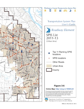
FERN HIL L RD TONGUE LN MINTER B RIDGERD BRID GE RD DAVIS RD TUALATIN VALLEY HWY 160TH AVE 53RD D 6 TH ST LOMBARD AVE BEAVERTON HILLSDALE HWY Top 11 Ranking SPIS
ALEXANDER ST
R
209TH AVE
KINNAMAN RD
5T HST
ROOD ROSEDALE RD 198TH AVE DENNEY RD RD locations
ALLENBLVD
SCOGGINS
IOWA
JOHNSON SCHO OL RD
HILL
BANY RD MURRAY BLVD SPIS locations
VALLEY
R D RD 155TH AVE OLESON
RD RIGERT RD
RIVER FA RMINGTON RD GRABHOR N RD 175TH AVE WEIR RD DAVIES RD 80TH AVE
\\Emcgis\nas\GISDATA\Workgroups\GISPlanning\TSP_2035\TSP_User_Guide\RoadwayElement\TSP_UserGuide_11x17_SPIS.mxd
UNGER RD NI MBUSA Other Roads
HILLSBORO
PATTON VALLEY RD
GASTON RD DIXON MILL RD HWY VE GREENB UR G RD OAK ST Urban Area
BALD PEAK RD C LARK HILL RD BAR ROWS RD 121ST AVE County
LAURELWOOD RD
LAUREL RD SCHOLLS FERRY RD BULL MOUN TAIN RD HALL BLV D 72 ND AVE
GAA RDE ST
SPRING
ROY ROGERS RD BEEF B END RD PACIFIC HWY DURHAM RD
HILL
RD
This map displays reference information that is not adopted by EL SNER RD TUALATIN RD
Washington County ordinance. It is not to be considered as SEIFFERT RD TETON
the official Washington County Transportation System Plan. CIPOL E RD HERMAN RD SAGERT ST
Please contact Washington County Long Range Planning at AVE Figure 3-6
ELWERT RD FER RD 65TH AVE Online Map: http://arcg.is/1NN6KcH
(503) 846-3519 with any questions regarding this map. EDY RD A VERY ST
for, or be suitable for legal, engineering, or surveying purposes. Users
of this information should review or consult the primary data and information
PINEST
CHAPMAN RD SUNSET BLVD TONQUI N R D GRAH AMS FERRYRD RY BOONES This product is for informational purposes and may not have been prepared
sources to ascertain the usability of the information. Care was taken
D in the mapping but there are no warranties for this product. However,
BROOKMAN R notification of any errors will be appreciated.
1 inch represents 12,000 feet ELLIGSEN RD
0 1.25 2.5
Department of Land Use & Transportation
Miles
Planning and Development Services Division
Effective: November 27, 2015