
Page 87 - TransportationPlanUsetsGuide
P. 87
ROY RD
185TH AVE
HILLSIDE RD
SCOTCH CHURCH RD
KEMPER RD MEEK RD
WREN RD WEST UNION RD
LAIDLAW R D
EVERGREEN RD K AISER THOMPSON RD
PURD IN RD
RD HORNECKER RD 15TH AVE 25TH AVE RD Transportation System Plan
MARTIN SAL T ZMA NRD User’s Guide
CORNELL RD
GALESC REEK RD
158TH AVE LEAHYR D
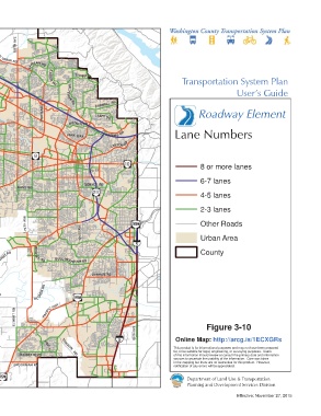
MAIN ST Roadway Element
RITC HEY RD B ST ELM ST BUTNER RD
LOIS ST
BARNES RD Lane Numbers
ST RINGTOWN RD
P ARK WA Y
CANYON RD
GOL
F CO URSE RD
TONGUE LN RD BL VD 8 or more lanes
FERN HILL RD IOWA BRIDGE 209TH AVE 5TH ST
ROOD CENTURY BANY RD DENNEY RD 6-7 lanes
JOHNSON SCHOO L RD
4-5 lanes
HILL R D
SCOGG INS VALLEY RD
UNGER RD 2-3 lanes
FARM INGTON RD
PATTON VALLEY R D GRA
AVE 5TH Other Roads
CLARK HILL RD RD 17 121ST AVE Urban Area
DIXON MILL RD
B HORN
\\Emcgis\nas\GISDATA\Workgroups\GISPlanning\TSP_2035\TSP_User_Guide\RoadwayElement\TSP_UserGuide_11x17_LANES.mxd
BALD PEAK RD RIVER RD
LAURELWO ODR D
SCHOLLS F ERRYRD
LAUREL RD ROSH A K RD County
BULL MOU NTAIN RD
DURHAM RD
E L SNER R D
SCHOLLS-S HER WOOD RD
SEIFFERT RD
This map displays an unofficial representation of elements HWY
adopted as part of Washington County Ordinance No. 783. It PACIFIC HWY
is not to be considered as the official Washington County HILLSBORO ELWERT RD
Transportation System Plan. Please contact Washington EDY RD Figure 3-10
County Long Range Planning at (503) 846-3519 with any 65TH AVE
questions regarding this map. Online Map: http://arcg.is/1ECXGRs
This product is for informational purposes and may not have been prepared
TONQUIN
for, or be suitable for legal, engineering, or surveying purposes. Users
PINE ST
CHAPMAN RD SUNSET BLVD RD of this information should review or consult the primary data and information
sources to ascertain the usability of the information. Care was taken
in the mapping but there are no warranties for this product. However,
BROOKMAN R D notification of any errors will be appreciated.
1 inch represents 10,000 feet
0 1 2
Department of Land Use & Transportation
Miles
Planning and Development Services Division
Effective: November 27, 2015