Fort Casey Military Reservation / Fort Casey State Park
Address: South Fort Casey Road
Date of Construction: c. 1900
Modifications made in: N/A
Original Use: Military Reservation
2006 Use: Recreation/education
Public Accessibility: Yes
History: On September 22, 1866, an Executive Order was enacted to reserve 22 tracts of land within Washington Territory for military purposes. Among the sites were 640 acres at Admiralty Head. An act of June 6. 1896 by Congress authorized the Secretary of War to allocate funds for construction of gun emplacements at Admiralty Head.
Description: Admiralty Head Lighthouse (1901): Brick frame set on brick foundation; irregular (30’ x 18’); 4 bays wide; 2 1/2-stories.
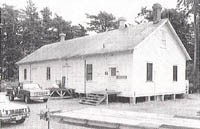
Remodeled Infirmary (1903): Wood frame set on concrete foundation; rectangle (45’ x 18’); 4 bays wide; 1-story.
Engineer’s Storage (1989): Wood frame set on post and block foundation; rectangle (54’ x 22’); 6 bays wide; 1 1/2-stories.